Greenland Iceberg Survives Collision With Joe Island
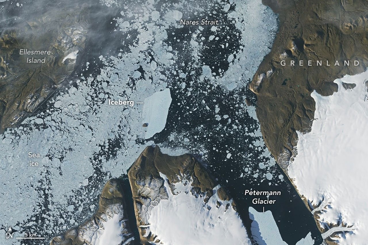
A large iceberg that calved from Greenland’s Petermann Glacier in August drifted into Nares Strait and collided with Joe Island, creating a striking example of how rapidly large pieces of polar ice can move through narrow Arctic waterways.
A remarkable journey from Petermann Glacier
NASA Earth Observatory reported that the iceberg broke away from Petermann Glacier in northwest Greenland during summer 2026. After leaving the glacier’s fjord, the tabular berg moved toward Nares Strait, a waterway between Greenland and Ellesmere Island that connects the Arctic Ocean with the waters farther south.
Satellite observations from Landsat 9 allowed scientists to follow the berg’s movement. Images captured on Aug. 23 and Aug. 24 showed the iceberg pivoting and becoming wedged against Joe Island. The sequence illustrates how ice that appears enormous and immovable from the ground can change position quickly when currents, wind, tides, and the geometry of coastal channels interact.
Why satellite monitoring matters
Large icebergs can create navigation hazards and complicate scientific understanding of glacier systems. Because their movement is difficult to observe continuously from the ground, satellites provide a valuable way to track their position over time and compare changing ice conditions across remote regions.
Landsat is particularly useful because its long-running record allows scientists to compare current observations with earlier images. The program, operated jointly by NASA and the U.S. Geological Survey, provides decades of land-surface observations that also reveal changes in glaciers, ice sheets, coastlines, lakes, and rivers.
Petermann Glacier remains scientifically important
Petermann Glacier has a long floating ice tongue extending toward the Arctic Ocean. Icebergs that calve from such systems can enter the ocean and then follow complex paths shaped by currents and coastal geography. The 2026 iceberg’s encounter with Joe Island therefore provides a detailed natural experiment in ice movement.
The event also demonstrates why a single satellite image rarely tells the whole story. Scientists can learn much more by comparing observations taken days apart. Changes in the iceberg’s orientation, position, and relationship with surrounding sea ice reveal the forces acting on it.
What the event says about Arctic change
Individual iceberg movements should not be treated as a simple measure of climate change. Icebergs calve naturally, and their paths depend on local conditions. But the broader decline and retreat of many glaciers and ice sheets remain important subjects of scientific observation.
For researchers, the value of this event is the detailed record it provides. For the public, it is a reminder that Earth’s frozen regions are dynamic systems rather than static landscapes. Continued satellite observations can help scientists understand how ice loss, ocean conditions, and atmospheric changes interact across the Arctic.
Sources and related reporting
Readers can follow related coverage in the Science section, World section, U.S. News section, Environment coverage, Health section, and the Hudson Tribune Newsroom.
Primary sources include NASA Earth Observatory, the USGS Landsat program, NASA Earth Science, the USGS Water Resources program, National Snow and Ice Data Center, and NASA Climate.