NASA Maps Hidden Freeze Stage Across the Arctic
A NASA-led study has mapped a little-known phase of Arctic ground freezing that can keep soils near the freezing point for days or weeks. The phenomenon, known as the zero curtain, may matter for understanding how permafrost responds to a warming climate.
What is the zero curtain?
Arctic soil does not always move directly from thawed to deeply frozen conditions. During autumn, freezing water releases heat, keeping nearby soil close to the freezing point before temperatures can fall further. During spring, melting ice can produce a similar effect by absorbing incoming heat.
The result is a period when soil remains near 0 degrees Celsius even as air temperatures change. Scientists call this the zero curtain. The phase can be important because soil moisture remains available while temperatures are suitable for microbial activity.
Why microbes matter
Microorganisms in frozen Arctic soils are not permanently inactive. When conditions become warmer and wetter, microbial decomposition can accelerate. That process breaks down organic material and can release carbon dioxide and methane.
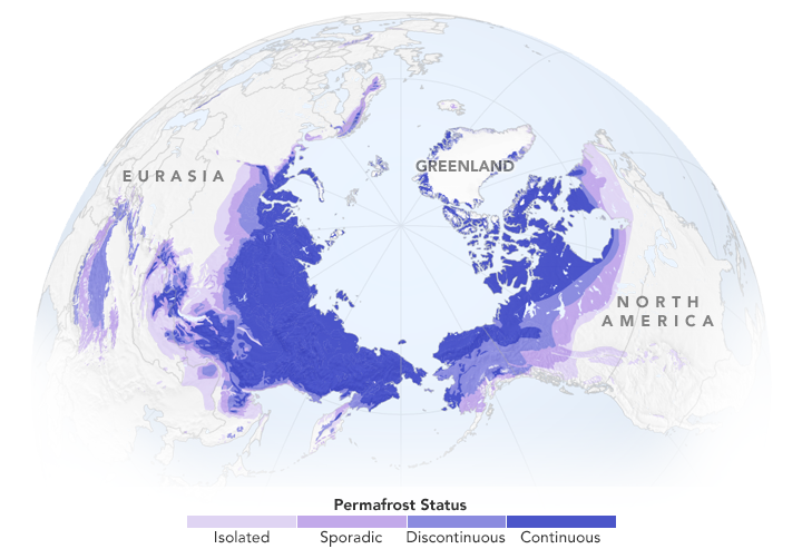
Permafrost contains enormous stores of organic carbon accumulated from plants and other material that decomposed slowly in cold conditions. NASA estimates that Arctic permafrost stores about 1.9 trillion tons of organic carbon, nearly twice the amount currently found in Earth’s atmosphere.
A new mapping approach
Researchers described an artificial-intelligence framework called GeoCryoAI that combines satellite observations, model outputs, and historical field measurements to map zero-curtain conditions across the Arctic region.
The study found that spring thaw generally produces longer zero-curtain periods than autumn freeze-up and that wetter areas tend to experience longer periods near the freezing point. These patterns can help researchers understand when soils may remain biologically active during seasonal transitions.
Why satellite data are useful
Large portions of the Arctic are difficult to monitor directly. Field observations are essential, but they are limited by distance, weather, logistics, and the size of the region. Satellite measurements provide a way to observe changes across broad areas and to connect individual field measurements with regional patterns.
The researchers also highlighted the potential of data from the U.S.-India NISAR mission. Synthetic aperture radar can detect changes in landscapes that may be difficult to observe with ordinary optical imagery, providing another tool for studying frozen ground.
Implications for climate models
Understanding the zero curtain matters because climate models need to represent when permafrost is frozen, thawed, wet, or biologically active. A transition period lasting several weeks can affect how much carbon is processed by microbes and when greenhouse gases may be released.
That does not mean every zero-curtain period produces the same emissions. Local soil composition, moisture, vegetation, temperature, and hydrology all influence microbial activity. The value of the new maps is that they give researchers a more detailed framework for studying those differences.
A closer look at a changing Arctic
The study illustrates how climate science increasingly depends on combining observations from satellites, field stations, historical records, and computational models. The Arctic is changing across many dimensions, and understanding those changes requires measurements that can connect processes occurring beneath the ground with conditions visible from space.
By mapping a stage of freezing that was previously difficult to observe at large scales, the research gives scientists another tool for investigating permafrost stability and the Arctic carbon cycle.
Sources and related reporting
Explore Hudson Tribune’s Science section, World section, Technology section, Health section, U.S. News section, and Newsroom.
Sources include NASA Science, NASA Earth Science, NASA Earth, USGS Landsat, NASA-ISRO NISAR, and National Snow and Ice Data Center.