Austria’s Pasterze Glacier Hangs on by One Icefall
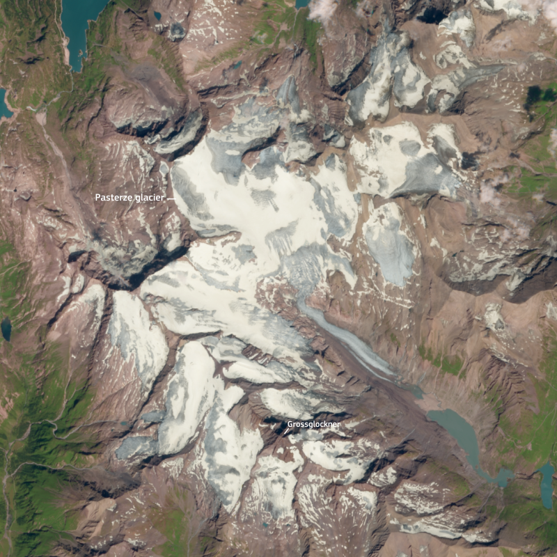
Austria’s largest glacier is approaching a striking physical change. NASA Earth Observatory reports that the Pasterze Glacier in the Eastern Alps is now connected between its upper and lower portions by only one narrowing icefall.
A shrinking connection
Satellite images comparing Aug. 22, 1985, with Aug. 15, 2026 show how dramatically the glacier’s structure has changed. Four decades ago, multiple icefalls connected the higher accumulation area with the lower glacier. In 2026, only the Hufeisenbruch icefall remained as a visible link.
That final connection may survive another year or two, depending on weather conditions, or it could disappear before the end of the current cold season. If the icefall breaks, the upper and lower portions of Pasterze would become physically separated, changing how the glacier is described and monitored.
Why one icefall matters
Glaciers behave like slow-moving rivers of ice. Their shape depends on the balance between snowfall, accumulation, melting, ice flow, and the surrounding terrain. A narrow icefall can therefore become an important structural bottleneck when a glacier is losing mass.
The Pasterze example is scientifically valuable because satellite imagery preserves a visual record of that transformation. Researchers can compare images collected decades apart to determine where ice has disappeared, where debris-covered sections remain, and how lakes and exposed ground develop as the glacier retreats.
Summer heat adds pressure
NASA described Europe’s summer of 2026 as exceptionally hot, creating conditions that have put additional stress on Alpine glaciers. Temperature alone does not determine a glacier’s fate, but prolonged heat can increase surface melting and reduce the amount of snow available to replenish ice.
Scientists also examine snowfall, dust, debris, elevation, and meltwater when assessing glacier health. These factors can interact. A darker surface can absorb more solar energy, while reduced snow cover can expose older ice earlier in the melt season.
What satellite records reveal
The Landsat program provides one of the most useful long-term records for studying changing landscapes. NASA and the U.S. Geological Survey use Landsat observations to monitor glaciers, vegetation, water bodies, coastlines, and other features over many years.
For Pasterze, the comparison between 1985 and 2026 makes the scale of structural change visible. It also shows why glacier science increasingly depends on combining field measurements with satellite observations. Field teams can measure ice directly, while satellites provide regional context and repeated observations.
A warning for Alpine water systems
Glacier retreat matters beyond scenery. Alpine ice contributes to river systems and can influence water availability, ecosystems, tourism, and hazards such as unstable slopes and glacial lakes. The effects vary by basin and season, so scientists avoid treating every glacier as if it responds identically.
Pasterze’s narrowing icefall is therefore more than a dramatic image. It is a measurable indicator of a changing cryosphere and a reminder that long-term scientific records can reveal transformations that are difficult to appreciate from a single visit.
Sources and related reporting
Hudson Tribune readers can follow the Science section, World section, U.S. News section, Health section, Lifestyle section, and the Newsroom.
Sources include NASA Earth Observatory, USGS Landsat, Copernicus, Copernicus Climate Change Service, NSIDC, and NASA Climate.