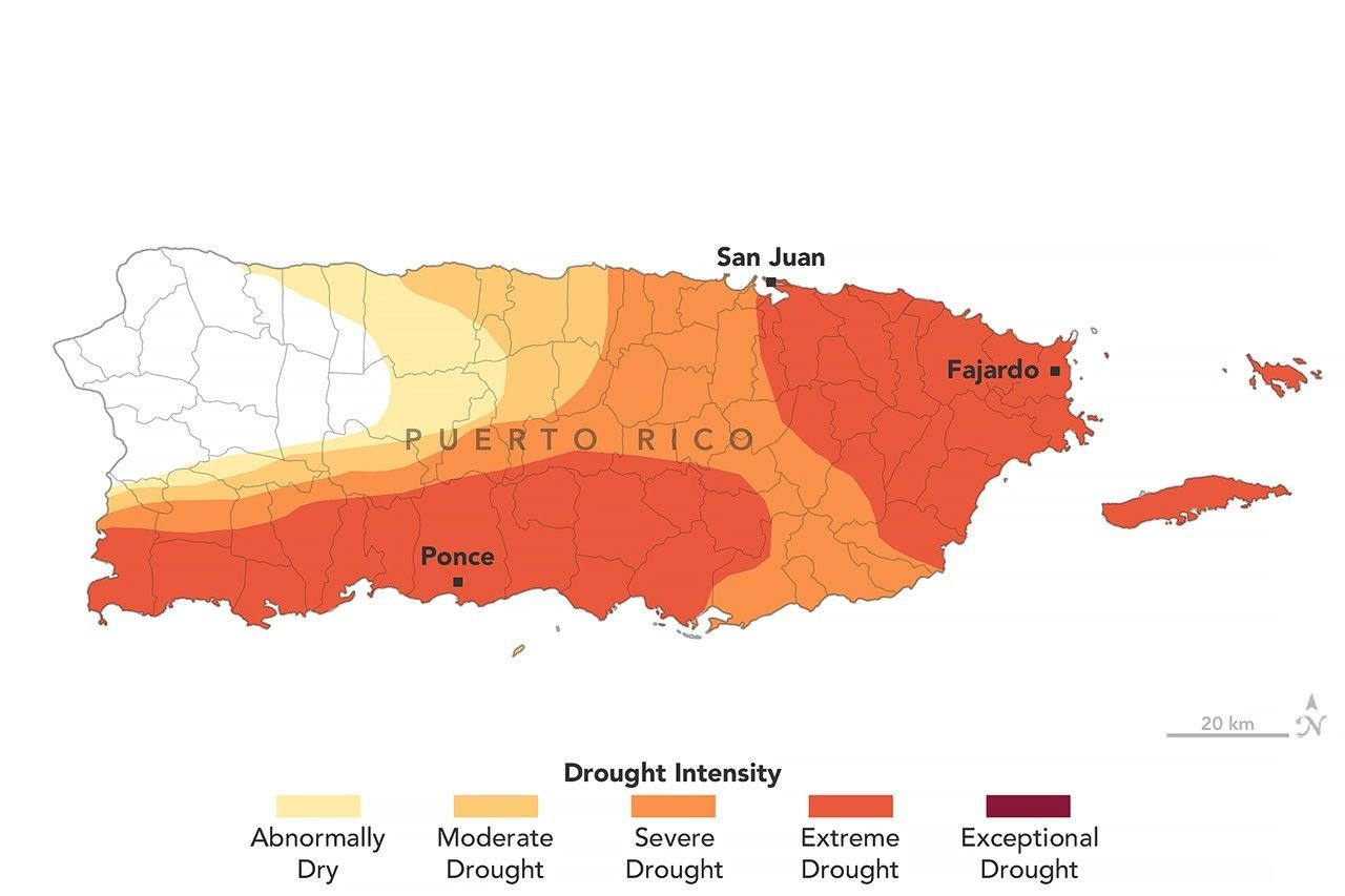
Puerto Rico Drought Deepens as Water Stress Spreads
Puerto Rico is facing a rapidly worsening drought as rainfall deficits and unusually high temperatures strain water supplies, agriculture, and communities. NASA’s latest Earth Observatory assessment, based on U.S. Drought Monitor data, shows how quickly conditions changed during 2026.
Dry conditions expanded quickly
As of Aug. 25, about three-quarters of Puerto Rico was experiencing at least moderate drought, while extreme drought covered 44% of the territory. Three months earlier, no part of the island was classified as being in drought. From mid-May through mid-July, much of Puerto Rico received less than 60% of normal precipitation, while some southern and southwestern areas received less than 20% of normal rainfall.
The numbers matter because drought is not simply a shortage of rain. High temperatures increase evaporation and water demand, while dry soils and declining streamflow reduce the amount of water available to farms, households, and ecosystems. NASA reported that rivers including the Rio Fajardo reached record-low flows during the recent dry period.
Water shortages are becoming a practical problem
Water rationing has been introduced in several municipalities, adding another layer of pressure for residents and local authorities. Puerto Rico’s governor declared a state of emergency in late July, and the U.S. government issued a drought disaster declaration covering more than two dozen cities and towns in late August.
Farmers face a particularly difficult combination of dry soil and high heat. NASA reported impacts on crops including bananas, coffee, cacao, and fruit trees, while ranchers have faced shrinking hay supplies. These effects show why drought monitoring has consequences beyond weather maps: changes in precipitation can move quickly into food production, household costs, and local economic activity.
Satellites help scientists see the wider pattern
The U.S. Drought Monitor combines satellite observations with weather, soil-moisture, streamflow, and well data. NASA scientists are now contributing directly to the weekly assessment process, adding Earth-observation expertise to a system used by governments and emergency planners.
For scientists, the value of satellite observations is partly their scale. Ground stations provide detailed information at specific locations, while satellites can help reveal how dryness is spreading across an entire region. Combining the two approaches gives decision-makers a more complete picture of drought severity and its likely effects.
Why the 2026 drought deserves attention
The Puerto Rico episode also illustrates why drought can intensify rapidly after a relatively wet season. NASA noted that conditions were wetter than normal across the U.S. Caribbean during late winter and early spring before rainfall dropped sharply. The transition demonstrates that short-term averages can hide major changes within a single season.
For residents, the immediate concern is reliable access to water. For scientists and planners, the broader challenge is determining how precipitation, temperature, soil moisture, streamflow, and infrastructure interact. Continued monitoring can help identify where conditions are deteriorating and where emergency resources may be most needed.
Sources and related reporting
Hudson Tribune readers can follow related coverage through the Science section, World section, Health section, U.S. News section, Lifestyle section, and the Hudson Tribune Newsroom.
Primary reporting is available from NASA Earth Observatory, the U.S. Drought Monitor, NOAA National Centers for Environmental Information, National Integrated Drought Information System, U.S. Department of Agriculture, and NASA Earth Science.